Steeped in history and blended in culture, historical sites in Pakistan reflect the tradition and way of life of the era gone by. There are many historical sites in Pakistan that make an excellent tours.
ads
Saturday, December 12, 2020
Ganish Hunza
Old historical village which is not maintained at all. They have spotters outside that call this guy who comes out right when they see a Non local arriving to see the place. This guy approached us pretty aggressively & demanded we have to pay 500 rupees entrance without any greetings or welcome. Upon paying that amount he took us through a total of 4 buildings that are approximately few meters apart and explains the history. We spent about 10 minutes listening to him & once he was done the tour was finished & we could go roam around the whole village on our own. Now we had thought that he will give us a tour of the whole village since we were 4 people & each paid about 500 a pop but that wasn't the case. The tour was basically just to justify the "Entrance" fee & nothing more. We saw old buildings that were locked filled with Garbage & filth so its pretty clear that the money they charge doesn't goes towards maintaining the place but into their own pockets. Funniest part was when my husband asked the man why there's an entrance fee to a village & he got even more aggressive & said there's No Why's here. There was nothing special about this place except some old wood art work & smelly alleyways with Garbage everywhere. The pond outside was the filthiest water pond I've ever seen. Kids were bathing in it on one side, other side a man was rinsing his mouth in the same water & besides him a woman was dipping a mop into the water to clean the mop. If we hadn't had visited this place we would not have missed anything. Definitely not worth spending your time & money on this place.
Thursday, December 10, 2020
Shishper Glacier
Shishper is a surging, or advancing, glacier. It formed around the beginning of the twentieth century, when what was then the Hassanabad glacier in the north of the Hunza valley split into two. Machuhar is the other glacier formed by this split. Like the overwhelming majority of glaciers in the Hindu Kush Himalayas, Machuhar is receding due to the warming caused by climate change. There are over 15,000 glaciers in this tallest and youngest mountain range of the world, which stretches from Afghanistan to Myanmar. The number keeps changing as receding glaciers split into two or more.
Tuesday, September 27, 2016
Khaplu Fort
Khaplu Palace was built in 1840 by the Yabgo Raja Daulat Ali Khan of Khaplu[4][9] after the Dogra of Kashmirwho captured the region decided to move the seat of government from the old fort. The site of the palace was chosen by rolling a large stone down from a nearby cliff; it stopped at the Doqsai village, and the palace was built there.[6] The earlier fort was located near the location of the present-day palace. Khaplu Palace replaced the former fort as the royal residence after its completion.[4][9] According to Jane E. Duncan, the people of Khaplu used to live inside this fort and were not allowed to build their homes outside its premises. This practice was changed after Maharaja of Kashmir took control of the area, resulting in a cessation of conflict among neighbouring rulers.[10]
The former fort was captured by Murad Khan of Maqpon Dynasty, the ruler of Baltistan, in the Conquest of Khaplu in the 1590s[11] by cutting off the water and other supplies to the fort. The troops of Murad besieged the fort for three months, resulting in the surrender of Rahim Khan, the 62nd Yabgo dynasty ruler of Khaplu. The fort again fell to invaders in the 1660s and 1674.[7]
The Yabgo descendants continued to live there even after their kingdom was abolished in 1972. The last Raja of Khaplu who lived in the house was Raja Fatah Ali Khan, who died in 1983.
The town of Khaplu is located in the eastern part of Baltistan, at an altitude of 2,600 metres (8,500 ft) above sea level and is the administrative capital of the Ghanche District. River Shyok a tributary of River Indus, passes through the town, along which is the ancient trade route to Ladakh.[4] Khaplu Palace is located north of the Khaplu town and south of the Shyok river[5][6] in front of the high mountains of Karakoram range.[7] A trek behind the palace in a ravine leads to the village of Pari in Skardu.
deosai national park
The Deosai National Park was established in 1993 to protect the survival of the Himalayan brown bear and its habitat. Having long been a prize kill for poachers and hunters, the bear now has a hope a
for survival in Deosai where its number has increased from only 19 in 1993 to 40 in 2005. During the last decade, a few but effective measures have been taken by the Government of Pakistan for the survival of brown bear in the region. In 1993, Himalayan Wildlife Project was founded with a substantial financial support from international environmental concerns. But the brown bear is still under threat.
The Deosai Plains are also home to the Himalayan ibex, red fox, golden marmot locally called Phia, gray wolf, the Ladakh urial, the snow leopard, and over 124 resident and migratory birds. Birds in the park include the golden eagle, lammergeier, griffon vulture, laggar falcon, peregrine falcon, kestrel, sparrowhawk andsnowcock. The following species are found in Deosai Artemisia maritima, Polygonum affine, Thalictrum alpinum, Bromus oxyodon, Saxifraga flagellaris, Androsace mucronifolia, Aster flaccidus, Barbarea vulgaris, Artemisia maritima, Agropyron longearistatum, Nepeta connate, Carex cruenta, Ranaculyus laetus, Arenaria neelgerrensis, Astrogalus leucophylla, Polygonum amplexinade, Echinop nivetus, Seria chrysanthenoides, Artemisia maritima, Dracocephalum nutsus, Anapalas contorta, Chrysopogon echinulatus, and Dianthus crinitus. There were also observed some medicinal plants which are locally famous i.e. Thymu linearis (Reetumburuk), Saussures lappa (kuth), Ephedra intimedia (Say), Viola canescens (Skora-mindoq), Dracocephalum muristanicum (Shamdun) and Artemisia maritima (Bursay) etc. are used as traditional drug therapies.
Tuesday, October 2, 2012
ATTA ABAD LAKE
Attabad Lake,, also known as Hunza Lake, is a lake in the Hunza Valley of northern
Pakistan created in January 2010 by a landslide dam.
The lake was formed due to a massive landslide at Attabad village in Gilgit-Baltistan, 9 miles (14 km) upstream (east) of Karimabad that occurred on January 4, 2010. The landslide killed twenty people and blocked the flow of the Hunza River for five months. The lake flooding has displaced 6,000 people from upstream villages, stranded (from land transportation routes) a further 25,000, and inundated over 12 miles (19 km) of the Karakoram Highway. The lake reached 13 miles (21 km) long and over 100 metres in depth by the first week of June 2010 when it began flowing over the landslide dam, completely submerging lower Shishkat and partly flooding Gulmit. The subdivision of Gojal has the greatest number of flooded buildings, over 170 houses and 120 shops. The residents also had shortages of food and other items due to the blockage of the Karakoram Highway. By June 4 water outflow from the lake had increased to 3,700 cu ft/s (100 m3/s).
Victims of the landslide and expansion of the lake staged a sit-in protesting the lack of government action and compensation payments to them.
As a result of the damming of Hunza River, five villages north of the barrier were flooded. One village, Ayeenabad, was completely submerged. Major portions of another village, Shishkat, was also submerged. Around 40% of the village of Gulmit, which also serves as the headquarter of Gojal Valley, was also submerged. Significant portions of land in Hussain and Ghulkin villages of Gojal also got submerged as a result of the surging lake.
The entire population of Gojal valley, up to 25000 individuals, were affected as a result of the lake, due to blockade of road access, difficulties in reaching to markets, loss of land, houses and agricultural products.
Attabad has been visited by current and former Prime Ministers Yousuf Raza Gillani and Nawaz Sharif, and by the Chief Minister of Punjab Shahbaz Sharif, Sharif announced Rs100 million of aid for the victims from the Punjab government and Rs0.5 million for the relatives of those who died in the landslide
Attabad Lake in May 2010
Attabad Lake in August 2011
Areas downstream from the lake remained on alert despite some officials believing that a major flood scenario was less likely as the river began flowing over the landslide dam during the first week of June 2010. Many people have been evacuated to 195 relief camps.Two hospitals downstream, the Kashrote Eye Vision Hospital and the Aga Khan Health Service, evacuated both their staff and equipment. Some officials had incorrectly predicted that as soon as the lake began flowing over the landslide dam, a 60 feet (18 m) wave would hit the areas immediately downstream.
As of 14 June 2010, the water level continued to rise. DawnNews reported that " 242 houses, 135 shops, four hotels, two schools, four factories and several hundred acres of agricultural land" had been flooded, and that villagers were receiving food and school fee subsidies. They reported that 25 kilometres of the Karakoram Highway and six bridges were destroyed.A special documentary on this issue Hunza Kahani by Waqar Ahmed Malik was on aired at Express news.
The spillway of the lake was blasted first on March 27, 2012 and then on May 15, 2012. It caused a reducation in its water level by at least 33 ft as performed by Frontier Works Organization.
Ethnic aspect of the lake disaster
The lake in September 2011.
The Gojal Valley, which is worst affected as a result of this lake, is home to three rare ethnic groups, namely Wakhi (70%), Burushaski (28%) and Domaki (2%). The entire population of Domaki speakers, a very tiny minority and historically marginalized community, was displaced from their village (Shishkat).
The Wakhi and Burushaski speaking minority ethnic groups have also been affected severely as a result of the disaster.
The National Monument in Islamabad,
national
monument
representing the
four provinces
and three territories of Pakistan.
Designed by Arif Masood the blooming flower shape of the monument
represents Pakistan's progress as a rapidly developing country.
The four main petals of the monument represent the four provinces
(Balochistan, North West Frontier Province, Punjab, and Sindh), while the
three smaller petals represent the three territories (Northern Areas, Azad
Kashmir and the Federally Administered Tribal Areas).
Saturday, October 22, 2011
Monday, September 13, 2010
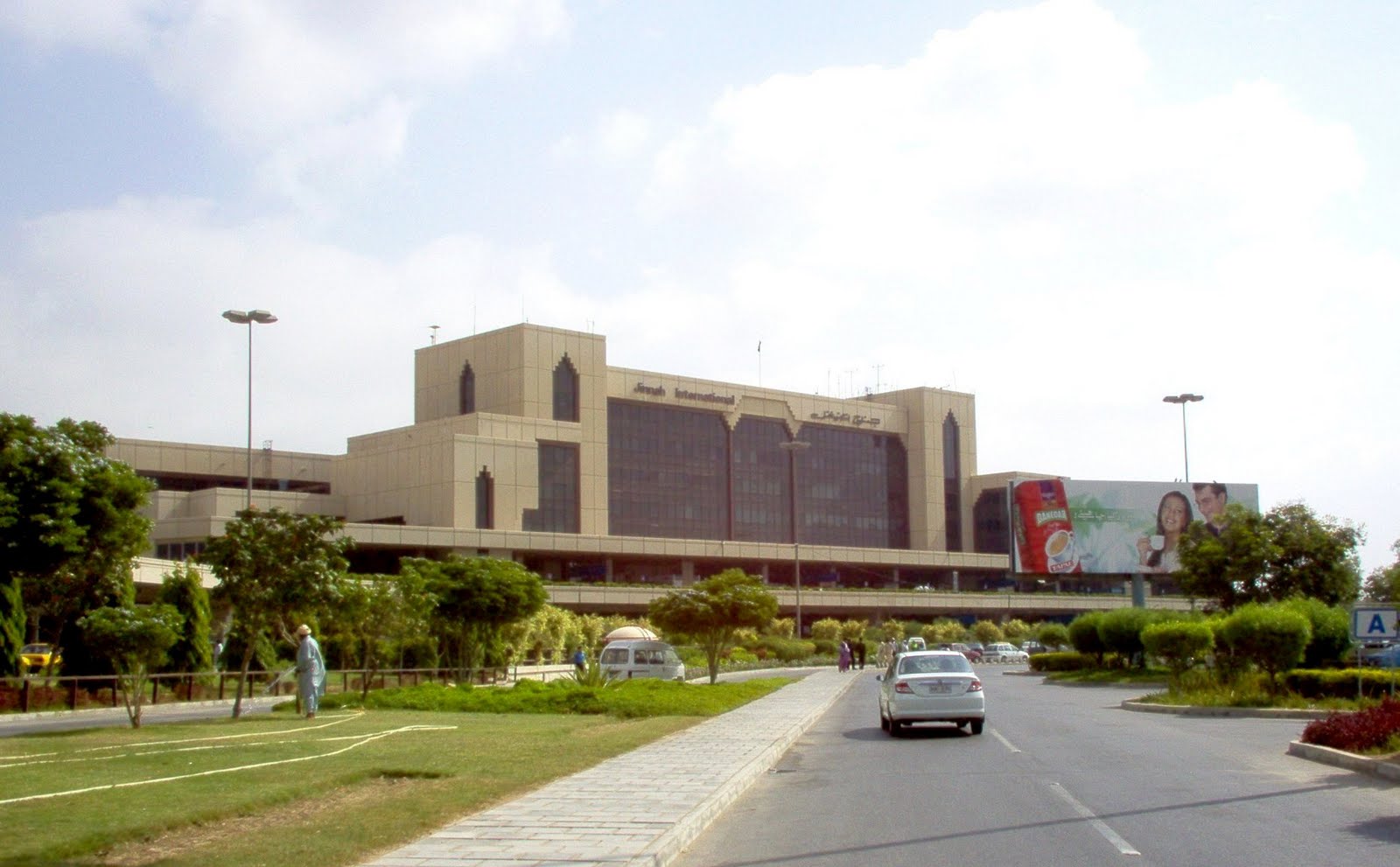
Jinnah International Airport

Jinnah International Airport
Jinnah International Airport previously Quaid-e-Azam International Airport (IATA: KHI, ICAO: OPKC) is Pakistan's largest international and domestic airport. It is located in Karachi, Sindh, and is also commonly known as the Jinnah Terminal. The airport is named after Muhammad Ali Jinnah, the founder of Pakistan, who was also known as Quaid-e-Azam ("Great Leader").
The airport provides primary hub for the flag carrier, Pakistan International Airlines (PIA), Shaheen Air International, and Airblue as well as many other private airlines. The airport is equipped with aircraft engineering and overhauling facilities including the Ispahani Hangar for wide-body aircraft.
History
During the 1940s there was a large black coloured hangar (also locally known as Kala Chapra) at the site of Karachi Airport, constructed for the British R101 Airship. Only three hangars were ever built in the world to dock and hangar the R101 airships. However, the R101 airship never arrived in Karachi (then part of the British Raj) as it crashed early in its journey in France. This hangar was so huge that aircraft often used it as a visual marker while attempting VFR landings at Karachi. Over the years, the hangar became known as the landmark of Karachi, until it was torn down by order of then-President Ayub Khan in the 1960s.
During World War II, Karachi Airport was a major transhipment base for United States Army Air Force units and equipment being used by Tenth Air Force in eastern India and Burma, as well as for Fourteenth Air Force in China. Several operational bomber and fighter units flew into Karachi for short organizational periods prior to their deployment. Air Technical Service Command had extensive facilities where aircraft were received, assembled and tested prior to being flown to their combat units at forward airfields. It also functioned as a major maintenance and supply depot for both air forces. In addition, Air Transport Command flew numerous cargo and passenger flights to the Middle East and to points within India and China.
The airport facilities were further expanded in the 1980s to Terminal 2 and Terminal 3 respectively. The present day infrastructure of Jinnah International Complex is a result of an expansion programme carried out in 1994. Today, the new Jinnah Terminal handles both domestic and international flights, whereas Terminal 2 is now dedicated to Hajj operations. Terminal 1 (which was actually the entirety of the airport in the British days) as well as Terminal 3 are now used for commercial offices, airline offices, and a string of bank counters and ATMs for public use.
Karachi was once a much busier airport. Between the 1960s and 1980s it was an online station of several major airlines of the world including British Airways, Interflug, TAROM, Alitalia, JAT Yugoslavia Airlines, Aeroflot, Philippine Airlines, Nigeria Airways, Ethiopian Airlines, EgyptAir, East African Airways, Kenya Airways, Air France, Qantas, Pan Am, Royal Jordanian, Libyan Arab Airlines, Japan Airlines, Syrian Arab Airlines, Middle East Airlines, Swissair, and SAS. However, due to the emergence of Dubai's airport on the world map, increased usage of longer haul aircraft, and the poor political climate of Karachi during the 1990s, several airlines discontinued their service to the airport.
In the past couple of years Karachi has seen a reversal in fortunes. The dwindling numbers of international airlines have stabilised and whilst there hasn't been a marked increase in the number of airlines flying in to Karachi, some have either increased the number of flights or resumed their old operations, either online or via codeshare service.
Economic factors may be partly responsible for the upswing in activity at the airport. As industrial growth in Karachi and the rest of Pakistan expands, some European and Asian carriers are mooting resumption of services to Jinnah International.
Structure
In fiscal year 2007-2008, over 26.6 million passengers used Jinnah International Airport. 249,283 aircraft movements were registered Jinnah International Airport in Karachi has always been the largest aviation facility in Pakistan. It is the primary hub of Pakistan International Airlines (PIA). All other Pakistani airlines also use Jinnah International Airport as their main hub. These include airblue and Shaheen Air International, as well as several charter carriers.
The building is linked via connecting corridors to two satellites, each having a provision of eight passenger-loading bridges. The eastern satellite is devoted exclusively to handling international operations. The western satellite is used for domestic operations, as well as some international operations. This is achieved through a flexible arrangement of gates. The two satellites supplement the departure lounges of the terminal building and also provide shopping facilities and snack counters.
The Jinnah Terminal was completed in 1992 at a cost of US $100 million - at the time the most expensive civil construction project in Pakistan[citation needed]. NESPAK (National Engineering Services Pakistan) and Airconsult (Frankfurt, Germany) were responsible for the architecture and planning of the terminal. Sogea Construction, a French company, was the contractor. Mukhtar Husain (NESPAK) was the Chief Architect for the new terminal.
In Karachi, the CIP Lounge can be used by all first and business class passengers on all outbound flights. Private banking clients of MCB Bank Ltd can also use the lounge on complimentary basis under contract to CAA as part of their benefits package. Only passengers who have been pre-issued an airline card from the check-in desk can enter the lounge. Other passengers who wish to use the lounge may do so upon payment of charges of USD 6.00 (international) or PKR 100/- (domestic). The lounge features light savoury snacks and non-alcoholic beverages, satellite TV, audio entertainment, newspapers, magazines, telephones, fax facilities, wireless Internet, and mobile charging points. There are also two McDonald's kiosks located on-site at the airport. airblue has also introduced their own lounge in the international terminal of the airport.
There are a number of banks that passengers can use at the airport including Askari Bank, Barclays, Citibank, Habib Bank, National Bank of Pakistan, MCB Bank, Royal Bank of Scotland, Standard Chartered Bank, and United Bank; which offer ATMs, foreign exchange facilities, traveler's cheque encashment, and personal banking. Private banking clients of Barclays worldwide (high net-worth individuals) now have their dedicated lounge as well. It features a hot buffet, speciality coffees, multimedia entertainment, shower and spa facility, and concierge service.
The airport is also where the majority of PIA's maintenance network is located, although some of its maintenance work also takes place at Benazir Bhutto International Airport, Rawalpindi. There are several hangars at the airport; the largest being the Ispahani Hangar (named after Mirza Ahmad Ispahani, the first chairman of PIA) that can accommodate two Boeing 747s and one narrow body airliner (e.g. Boeing 737) at one time. On 15 February 2006, the first major overhaul of a Boeing 777-200ER aircraft (known as "C" check) was done at Ispahani Hangar. Most of the PIA aircraft are checked and regulated at the aircraft hangars in Karachi. The PIA maintenance also check other airline aircraft in Karachi such as Philippine Airlines, Turkish Airlines, and Air Universal.
PESHAWAR
Peshāwar Persian is the capital of the North-West Frontier Province and the administrative centre for the Federally Administered Tribal Areas of Pakistan. Peshawar" literally means "The Place at the Frontier" in Persian and is known as Pekhawar in Pashto or Pukhto. The area of the city has been ruled by numerous empires including the Afghan, Persian, Shahi, Greek, Maurya, Scythian, Arab, Turk, Mongol, Mughal, Sikh and the British.
In ancient times, a major settlement called Purushpur was established by Kanishka, the king of the Central Asian Kushans, in the general area of modern Peshawar. Purushpur emerged as a major center of Buddhist learning until the 10th century, and was the capital of the ancient Indo-Greek kingdom of Gandhara. During that time, the Kanishka stupa on the outskirts of Peshawar, was the tallest building in the world - rising to almost 700 feet.
The current city was established during the Mughal period in the 16th century by Akbar during which it received the name Peshawar. During much of its history, the city was one of the main trading centres on the ancient Silk Road and was a major crossroads for various cultures between South Asia, Central Asia and the Middle East.
Located on the edge of the Khyber Pass near the Afghan border, Peshawar is the commercial, economic, political and cultural capital of the Pashtuns in Pakistan. It is as a geographical and cultural frontline between extremist, moderate, and liberal Islam.
History of Peshawar
Being among the most ancient cities of the region between Central, South, and West Asia, Peshawar has for centuries been a centre of trade between Afghanistan, South Asia, Central Asia and the Middle East. As an ancient center of learning, the 2nd century B.C.E. Bakhshali Manuscript used in the Bakhshali approximation was found nearby. Peshawar is also the setting of the famous story Peshawar Nights, which was an exchange between a Shia scholar and a Sunni audience over the course of eleven nights, which presumably resulted in their acceptance of Shi'ism.
Peshawar was a major center of Buddhist learning until the 10th century. As an indication of its importance, Peshawar was also the site of Kanishka's Great Stupa which housed relics from Gautama Buddha, and was widely considered to be the tallest building in the world at the time of its construction. Ancient Chinese manuscripts tell of Buddhist pilgrims such as Faxian, Sung Yun, and Xuanzang reporting that the 7th century stupa, which was rediscovered in 1908, had a height of 591–689 feet.
Indo-Greek Peshawar
The area that Peshawar occupies was then seized by the Greco-Bactrian king, Eucratides (170 - 159 BCE), and was controlled by a series of Greco-Bactrian and later Indo-Greek kings who ruled an empire that spanned from ancient Pakistan to North India. Later, the city came under the rule of several Parthian and Indo-Parthian kings, another group of Iranic invaders from Central Asia, the most famous of whom, Gondophares, ruled the city and its environs starting in circa 46 CE, and was briefly followed by two or three of his descendants before they were displaced by the first of the "Great Kushans", Kujula Kadphises, around the middle of the 1st century CE.
Kanishka's Rule
Peshawar formed the eastern capital of the empire of Gandhara under the Kushan king Kanishka, who reigned from at least 127 CE. Peshawar became a great centre of Buddhist learning. Kanishka built what may have been the tallest building in the world at the time, a giant stupa, to house the Buddha's relics, just outside the Ganj Gate of the old city of Peshawar.
Excavations of Kanishka's Monastery in central Peshawar
The Kanishka stupa was said to be an imposing structure as one travelled down from the mountains of Afghanistan onto the Gandharan plains. The earliest account of the famous building is by the Chinese Buddhist pilgrim monk, Faxian, who visited it in 400 and described it as being over 40 chang in height (probably about 120 m or 394 ft) and adorned "with all precious substances". "Of all the stûpas and temples seen by the travellers, none can compare with this for beauty of form and strength." It was destroyed by lightning and repaired several times. It was still in existence at the time of Xuanzang's visit in 634. From the ruined base of this giant stupa there existed a jewelled casket containing relics of the Buddha, and an inscription identifying Kanishka as the donor, and was excavated from a chamber under the very centre of the stupa's base, by a team under Dr. D.B. Spooner in 1909. The stupa was roughly cruciform in shape with a diameter of 286 feet (87 meters) and heavily decorated around the sides with stucco scenes.
Sometime in the 1st millennium BCE, the group that now dominates Peshawar began to arrive from the Suleiman Mountains of southern Afghanistan to the southwest, the Pashtuns. Whether or not the Pashtuns existed in the region even earlier is debatable, as evidence is difficult to attain. Some writers such as Sir Olaf Caroe write that a group that may have been the Pakhtuns existed in the area and were called the Pactycians by Herodotus and the Greeks, which would place the Pakhtuns in the area of Peshawar much earlier along with other Aryan tribes. Ancient Hindu scriptures such as the Rig-Veda, speak of an Aryan tribe called the Pakht, living in the region.
Regardless, over the centuries the Pakhtuns would come to dominate the region and Peshawar has emerged as an important center of Pakhtun culture along with Kandahar and Kabul as well as Quetta in more recent times. Muslim Arab and Turkic arrived and annexed the region before the beginning of the 2nd millennium.
Arrival of Islam
The Pakhtuns began to convert to Islam following early annexation by the Arab Empire from Khurasan (in what is today western Afghanistan and northeastern Iran).
Sebuktagin dying in 997 was succeeded as governor of Khorasan by his son Mahmud, who throwing of all dependence on the Samani princes, assumed the title of Sultan in 999, and from this reign the Hindu religion in these parts may be said to have received a death blow. In the early reign of this celebrated invader of India the plains of Peshawar were again the scene of some great battles, the first of which was fought on the maira between Nowshera and the Indus, in the year 1001. Mahmud was opposed by Jaipal, who had been constantly endevouring to recover the country wrested from him by Sebuktagin, still aided by some Pathans whose allegiance to the Muslim governor of Peshawar was not of long continuance.
The battle took place on November 27 and the Hindus were one again routed, Jaipal himself being taken prisoner, who upon his subsequent release resigned the crown to his son Anandpal. On this occasion Mahmud punished the Pathans who had sided with the enemy, and as they were now converted entirely to the Islam, they stayed true to their new allegiance, and joined the Sultan in his wars against the infidels.
Peshawar was taken by Turkic Muslims in 988 and was incorporated into the larger Pakhtun domains by the 16th century. The founder of the Mughul dynasty that would conquer South Asia, Babur, who hailed from current Uzbekistan, came to Peshawar and founded a city called Bagram where he rebuilt the fort in 1530. His grandson, Akbar, formally named the city Peshawar, meaning "The Place at the Frontier" in Persian and expanded the bazaars and fortifications. The Muslim technocrats, bureaucrats, soldiers, traders, scientists, architects, teachers, theologians and Sufis flocked from the rest of the Muslim world to Islamic Sultanate in South Asia and many settled in the Peshawar region.
Reigns of the Pashtun Kings
The Pakhtun conqueror Sher Shah Suri, turned Peshawar's renaissance into a boom when he ran his Delhi-to-Kabul Shahi Road through the Khyber Pass and Peshawar. Thus the Mughals turned Peshawar into a "City of Flowers" by planting trees and laying out gardens similar to those found to the west in Persia. Khushal Khan Khattak, the Pakhtun/Afghan warrior poet, was born near Peshawar and his life was intimately tied to the city. Khattak was an early Pakhtun nationalist, who agitated for an independent Afghanistan including Peshawar. As such, he was an implacable foe of the Mughal rulers, especially Aurangzeb.
After the decline of the Mughal Empire, by the 18th century the city came under Persian control during the reign of Nadir Shah. In 1747, following a loya jirga, Peshawar would join the Afghan/Pakhtun empire of Ahmad Shah Durrani as a Pakthun region. Pakhtuns from Peshawar took part in the incursions of South Asia during the rule of Ahmad Shah Durrani and his successors.
Decline Under Sikh Rule
Ranjit Singh lead the Sikh army and invaded Peshawar in 1818 after wresting it from Afghanistan - resulting in Peshawar's darkest times as a part of The Sikh Kingdom of Punjab. In the wars between to two nations, the city's population was decimated as up to half of its inhabitants were killed or expelled under the Sikh reign.The famous mosque at Ghor Khatri which was built by Jahan Ara Begum, daughter of Emperor Shahjahan, was destroyed by the Sikhs around 1823 and replaced with a temple to Gorakhnath, which remains until the present day
All but one of Peshawar's grand Mughal mosques were destroyed under Sikh rule. In contradiction to some Sikh sources, which continue to insist that no Sikh ever desecrated a mosque, of the many Mughal mosques that existed prior to the Sikh invasion, only the Mohabbat Khan Mosque survived Sikh depredations as it was used as an execution ground. Even there, the Sikhs destroyed the crowns of the minarets which had to be rebuilt later by the British
Sikh rule of the city from 1834 to 1843 was administered under an Italian general named Paolo Di Avitabile, whose reign was described as one of "gallows and gibbets".
British Gazetteers noted that General Avitable used the minarets of the famed Mohabbat Khan Mosque as gallows.[29][30][31] Despite claims that no Sikh desecrated a mosque, the desecration of Peshawar's mosques by their appointed administrator is well documented.
f the monuments of the Muslim period, too very few have survived our own times, not because the Muslim kings were not endowed with architectural tastes and talents or that they did not construct any attractive edifices, but because everything of architectural value that existed here was destroyed by the Sikhs, especially during Avitabile’s reign as the Governor of Peshawar. The only buildings of any antiquity and historical interest are the Gor Khatri, also called Serai Jahanabad, and the Mosque of Mahabat Khan. Even these did not escape the tyrant’s hand, while the mosque was desecrated and its lofty minars were used as gallows, the Serai was converted into the residence of the governor, and the mosque of Jahan Ara Begum built inside was replaced by a temple, which still stands there.
The Sikhs also proceeded to destroy Peshawar's own Shalimar Gardens, as well as burn a large portion of the city. They felled many trees in the city gardens for use as firewood. The Sikhs also destroyed much of the Bala Hisar Fort during their reign, but rebuilt it in its current form under the governance of Hari Singh Nalwa, briefly renaming it Samir Garh.
Colonial Peshawar
With the collapse of the Sikh Empire, following the passing by of Maharaja Ranjit Singh and the Sikh defeat in the second Anglo-Sikh War, the British occupied Peshawar, much to the relief of its citizens who had endured the brutal conditions of Sikh occupation.
The mountainous areas outside of the city were mapped out in 1893 by Sir Mortimer Durand, then foreign secretary of the British Indian government, who demarcated the boundary of his colony with the Afghan ruler at the time, Abdur Rahman Khan. It is now known as the Durand Line. The Kabul government has argued that the pact expired when British colonialists left the region - although claims to the region have not been a part of official Afghan policy.
Independence and Afghan Instability
In 1947, Peshawar became part of the newly independent state of Pakistan after politicians from the Frontier approved merger into the state that had just been carved from British India. While a large majority of people approved of this action, others believed in the unity of India, such as Abdul Ghaffar Khan. Still others believed that the province should have ascended to Afghanistan - a position which later evolved into a call for a state independent of both Pakistan and Afghanistan.
Until the mid-1950s, Peshawar was enclosed within a city wall and sixteen gates. Of the old city gates, the most famous was the Kabuli Gate but only the name remains to this date. Peshawar has not grown as much in size or capacity as the population has. As a result it has become a polluted and overcrowded city
After the Soviet invasion of Afghanistan in 1979, Peshawar served as a political centre for the anti-Soviet Mujahideen, and was surrounded by huge camps of Afghan refugees. Many of the refugees remained through the Afghan civil war, which broke out after the Soviets were defeated in 1989, antecedent to the rule of the Taliban, and the invasion by American and allied forces in late 2001. Peshawar would replace Kabul and Kandahar as the centre of Pakhtun cultural development during this tumultuous period. Peshawar managed to assimilate many of the Pakhtun Afghan refugees with relative ease, while other Afghan refugees have remained in camps awaiting a possible return to Afghanistan.
Peshawar continues to be a city that links Pakistan to Afghanistan as well as Central Asia and has emerged as an important regional city in Pakistan. It remains a focal point for Pakhtun culture. Today, like the surrounding region, it is at the crossroads of the struggle between the extremist Taliban and moderates, liberals and Pakhtun nationalists. As a demonstration of their determination to destroy Pashtun icons, the Taliban bombed the shrine of the most beloved Pashtun poet, Rahman Baba, in 2009.
Old City of Peshawar
The historic old city of Peshawar was once a heavily guarded citadel with high walls. Today, not much remains of the walls, but the houses and havelis have an essence of days gone by. Most of the houses are made of unbaked bricks with wooden structures for protection against earthquakes. Many of them have beautifully carved wooden doors and latticed wooden balconies. Areas such as Sethi Mohallah still contain many fine examples of the old architecture of Peshawar. There are many historic monuments and bazaars in the Old city, including the Mohabbat Khan Mosque and Kotla Mohsin Khan, Chowk Yadgar and the Qissa Khawani Bazaar.
The walled city was surrounded by several main gates which severed as the main entry points into the city, some of which still survive today. They include:
Lahori Gate
Sarasia Gate
Ganj Gate
Sirki Gate
Sard Chah Gate
Kohati Gate
Educational institutions
With the level of higher education on the rise, there has been a surge of prestigious educational institutions in Peshawar.
Abasyn University
Khyber Medical University
Institute of Management Sciences
Agriculture University of Peshawar
University of Engineering & Technology (U.E.T.)
National University of Computer and Emerging Sciences (FAST-NU), (Peshawar Campus)
Islamia College Peshawar (1913)
Gandhara University
Iqra University
Institute of Management Studies
ICMS
Oxfords College University Town Peshawar
City University Of Science & Technology
Institute of Business & Management Sciences
CECOS
Gandhara Medical College
Sarhad University
Ghulam IOshaq Khan Institute of Science & Technology, Topi, NWFP
College of Aeronautical Engineering (CAE, NUST), Risalpur, NWFP
Peshawar Medical College
University of Peshawar
Preston University
Greenwich University
PAC
Government Frontier College Peshawar
Jinnah College for Women
Edwardes College Peshawar
Government College Peshawar
Superior Science College Wazirbagh Peshawar.
Fazaia Degree College (PAF Degree College)
St. Francis' High School
University Public School (1964)
University Model School
Peshawar Model School
Collegiate School Islamia College
Oxfords College School University Town Peshawar
Peshawar Public School and College
The Convent High School
Army Public School
BeaconHouse School System
The City School
The Educators
The Roots School
American International School
I.L.M
The Smart School
Qadeems Educational System
Iqra School
daffodils Kindergarten (Hayatabad Town)
Frontier Model School
Peshawar Grammar School
Lahore Grammar School (Peshawar Campus)
Saint Mary's High School
Forward Model School
Forward Public School
Wednesday, January 20, 2010
Vedic period

Retracing shared heritage of India, Pakistan Written by Aditi Tandon, Tribune News Service.
Vedic period
The time period in the history of India known as the Vedic period or Vedic age is the period of the composition of the sacred texts called Vedas and other such texts in Vedic Sanskrit. The associated culture sometimes referred to as Vedic civilization was centered on the Punjab (modern Pakistan) and the Gangetic plain (modern India). Scholarship places the Vedic period into the 2nd and 1st millennia BCE, continuing up to the 6th century BCE when it began to be transformed into classical forms of Hinduism. Early medieval Hindu authors suggest dates as early as the 4th millennium BCE.
Its early phase saw the formation of various kingdoms of ancient India. In its late phase (from ca. 700 BCE), it saw the rise of the Mahajanapadas, and was succeeded by the golden age of Hinduism and classical Sanskrit literature, the Maurya Empire (from ca. 320 BCE) and the Middle kingdoms of India.
Gandhāra is the name of an ancient Indian Mahajanapada, currently in northern Pakistan (the North-West Frontier Province and parts of northern Punjab and Kashmir) and eastern Afghanistan. Gandhara was located mainly in the vale of Peshawar, the Potohar plateau (see Taxila) and on the northern side of the Kabul River. Its main cities were Peshawar and Taxila.
The Kingdom of Gandhara lasted from the 6th century BC to the 11th century AD. It attained its height from the 1st century to the 5th century AD under Buddhist Kushan Kings. After it was conquered by Mahmood of Ghazni in 1021 AD, the name Gandhara disappeared. During the Muslim period the area was administered from Lahore or from Kabul. During Mughal time the area was part of Kabul province.
Punjab
The Punjabis were predominantly Hindu with large minorities of Buddhists like the rest of South Asia, when Umayyad Muslim Arab army led by Muhammad bin Qasim attacked Sindh and lower Punjab, in 713. This started the process of Islamic conversion among the population of Punjab, as well as India . This process continued for the next 10 centuries but there were significant non-Muslim populations including Hindus and later Sikhs.
The heritage of Seraikistan - Bhutta Wahan
Is situated at a distance of 16 kilometers to the North of Rahim Yar Khan, on the lost river Hakra. The village is said to be named after the name of Raja Bhutta who captured this locality after Raja Dahir. This village is also claimed to be the birth place of Sassi, the renowned heroine of Sassi-Pannun and of Ab-ul-Fazal and Fiazi, sons of Mullah Mubarik.
Islamgarh Fort
Islamgarh ,the old Bhinwar Fort, was built by Rawal Bhim Singh in Sambat in 1665, as the following inscription on its gate in Babri characters proves "Samabat 1665 Asuj Wadi 2, Maharaj Rawal Sri Bhim Singh Ji Maharaj". The fort is situated in the Cholistan area of Tehsil Khanpur. It is 46 kilometers south east of Baghla Fort. The fort is in a dilapidated state.
Mau Bubarik Fort
According to Tarikh-e-Murad, a fort was built by Raj Hans Karar in Mau Mubarik as a residence for his mother, hence the name Mau refers to mother in local language. The fort was taken by Shah Arghun in 1525 A.D. It was one of the six fortresses of Raj Sahasi 11. It had 20 bastions and Towers. The ramparts were about 549 meters in circumference and the walls very strongly and thickly built. Here the shrine of a saint Sheikh Hakim is of great importance.
Pattan Minara
The ruins of Pattan Minara are located at a distance of about 8 kilometers in east south of Rahim Yar Khan city. It has variously been described as the remains of Ashoka period, who built it in 250 B.C. or a Buddhist monastery. Nearby the minar, remains of a fort, a mosque and some tunnels are also visible. About 110 years ago Colonel Minchin a political agent of Ex-Bahawalpur state started the excavation of these tunnels but discontinued digging for some reasons or other. According to Colonel Toy it was the capital of the Hindu kingdom in 10 A.D. In the mid of the 18th century A.D. Fazal Elahi Khan Halani a Daupauta chief destroyed it and used its materials in the construction of Bhagla and Dingarh Fort.
Faisal Mosque

Faisal Mosque
The Faisal Mosque in Islamabad is the largest mosque in Pakistan and South Asia and the fourth largest mosque in the world. It was the largest mosque in the world from 1986 to 1993 when overtaken in size by the completion of the Hassan II Mosque in Casablanca, Morocco. Subsequent expansions of the Masjid al-Haram (Grand Mosque) of Mecca and the Al-Masjid al-Nabawi (Prophet's Mosque) in Medina, Saudi Arabia during the 1990s relegated Faisal Mosque to fourth place in terms of size.
Faisal Mosque is the National Mosque of Pakistan. It has a covered area of 5,000 m2 (54,000 sq ft) and has a capacity to accommodate approximately 300,000 worshippers (100,000 in its main prayer hall, courtyard and porticoes and another 200,000 in its adjoining grounds). Although its covered main prayer hall is smaller than that of the Hassan II Mosque in Casablanca (the world's third largest mosque), Faisal Mosque has the third largest capacity of accommodating worshippers in its adjoining grounds after the Masjid al-Haram (Grand Mosque) of Mecca, the Al-Masjid al-Nabawi (Prophet's Mosque) in Medina. Each of the Mosque's four minarets are 80 m (260 ft) high (the tallest minarets in South Asia) and measure 10 x 10 m in circumference.
The Faisal Mosque is named after the late King Faisal bin Abdul Aziz of Saudi Arabia, who supported and financed the project.
History
The impetus for the mosque began in 1966 when the late King Faisal bin Abdul Aziz of
Saudi Arabia supported the initiative of the Pakistani Government to build a national mosque in Islamabad during an official visit to Pakistan. In 1969, an international competition was held in which architects from 17 countries submitted 43 proposals. After four days of deliberation, Turkish architect Vedat Dalokay's design was chosen. Construction of the mosque began in 1976 by National Construction of Pakistan, led by Azim Borujerdi, and was funded by the government of Saudi Arabia, at a cost of over 130 million Saudi riyals (approximately 120 million USD today). King Faisal bin Abdul Aziz was instrumental in the funding, and both the mosque and the road leading to it were named after him after his assassination in 1975. The mosque was completed in 1986, and used to house the International Islamic University. Many conservative Muslims criticised the design at first for its non-conventional design and lack of the traditional dome structure, but virtually all criticism was eventually silenced by the mosque's scale, form, and setting against the Margalla Hills upon completion.Location
It is located in Islamabad, the capital city of Pakistan. It is situated at the north end of Faisal Avenue, putting it at the northernmost end of the city and in front of a magnificent backdrop provided by the Margalla Hills, the westernmost foothills of the Himalayas. It is a focal point of Islamabad, and a famous and recognized icon of the city.
Design
The Faisal Mosque is the most famous work of renowned Turkish architect, Vedat Dalokay. The mosque's relatively unusual design fuses contemporary lines with the more traditional look of an Arab Bedouin's tent, with its large triangular prayer hall and four minarets. However, unlike traditional masjid design, it lacks a dome, and like a tent, the weight of the main prayer hall in the center is supported by the four minarets. The minarets borrow their design from Turkish tradition and are thin pencil like. The interior of this prayer hall holds a very large chandelier and its walls are decorated with mosaics and calligraphy by the famous Pakistani artist Sadequain. The mosaic pattern adorns the west wall, and has the kalimah writtern in early Kufic script, repeated in mirror image pattern.
The mosque's architecture is a departure from the long history of South Asian Islamic architecture. However, in some ways it makes a bridge between Arab, Turkish and Pakistani Islamic architectural traditions.
Kot Diji Fort


Kot Diji Fort
The Kot Diji Fort, formally known as Fort Ahmadabad, dominates the town of Kot Diji in Khairpur, Pakistan about 25 miles east of the Indus River at the edge of the Nara-Rajisthan Desert. The fort was built between 1785 to 1795 by Mir Sohrab Khan Talpur, founder of the Kingdom of Upper Sindh in 1783. In addition to the fort, a 5 kilometer, 12 feet wide mud wall was built around the city. This defensive wall had bastions throughout its length and a huge iron gate served as the city's only entrance.
Fort Kot Diji
Mir Sohrab Khan Talpur, King of Upper Sindh.1783-1830
Map of Sindh. Confederacy of Talpur KingdomsThe fort was considered invincible and served as the residence of the Ameers of Khairpur in times of peace. It is, therefore, the ancestral home of royal house. During war time the zenana (female members of the royal family), would be shifted to Shahgarh Fort, formerly within the realm but since 1843, after the conquest of the rest of Sindh, it is in the Jaisalmer desert, now in India. When the Zenana moved into the comfort of palaces, it stood mainly as a decorated reminder of more violent times. Throughout its whole history, however, Fort Kot Diji was never attacked.
Construction
Kot Diji is a very practical fort constructed on a limestone hill with kiln-baked bricks. Bricks were used because the locally available limestone rock was very brittle and would have shattered easily on impact with a cannonball. The hill is about 110 feet high, above which the walls of the fort rise another 30 feet. It has three strategically placed towers about 50 feet tall.
The fort is over half a kilometer long. Its walls are segmented by about 50 bastions, and its 1.8 km outer perimeter wall identically follows the double crescent-shaped contours of the hill it stands on. This allows the fort to surround the attacking enemy on three sides on the west front. On the east, where the entrance lies, the fort is divided by three elephant-proof gates into three overlapping levels, so that the first two levels can be attacked by the next level above them in the event of the lower level being overrun by the enemy. The first gate is not a prominent portal but rather an indirect entry so that the gate cannot be rammed on a charge. The walls and bastions have arrow slits in them, allowing defenders to attack their enemy from two levels: from the battlement on top and from within the wall.
The fort was built at a time when cannons had become common and its design and position reveals that. It includes a multitude of stations for cannons and, because it is positioned high on a narrow ridge, enemy cannons would have had to fire at a great distance, permitting little accuracy. Cannonballs could either hit the hill or perimeter or would simply fly over the fort and fall on the enemies' own forces on the other side.
Location
Kot Diji was located at the edge of the desert; this provided an advantage over enemies marching from the east, because an exhausted army could be met before it could take supplies and water from the irrigated lands. In fact, the Mirwah canal was built in 1790 specifically to irrigate the lands west of the fort and bring water to the military base.
Role under the British Empire
The Kingdom of Upper Sindh later was recognized by the British as the princely state of Khayrpur, after the East India Company had reduced its area to less than a third of its original size of over 50,000 km². The Fort was allocated the role of central military base for the Kingdom, especially to resist Afghan invasion. It was the strongest of the 20 or so Talpur forts and was named after the Persian architect Ahmed, who designed it. According to folklore it took 30 years to build; in reality, a much shorter, tactically feasible period may have been possible by mobilizing peasants and soldiers on a massive scale.
Recent history
After the merger of the State with Pakistan in 1955, the fort could have been included with the personal property of the Mir of Khairpur (as is the case with other ex-sovereign rulers who still possess their forts). However, Mir Ali Murad II thought it appropriate to hand it over to the government of Pakistan, expecting better maintenance. Since then, the fort has fallen into serious disrepair and is presently in a derelict condition. Most of the lime mortar plaster has fallen of the walls, leaving the bricks exposed. During the dictatorship of Ayub Khan, 192 cannons and mortars based at and collected in the fort were stolen or destroyed by being thrown from the bastions; other decorative fixtures and fittings were stolen as well. Apart from many indigenously made cannons, the collection included those built for Nadir Shah, the Kachar emperors, and the Kalhora, Mughal and Safavid dynasties, along with antique European cannons.
Prince Mehdi Raza exposes government corruption showing the use of sand instead of cement as mortar.Jan, 2006In 1994 the provincial government of Sindh leased out the limestone hill on which the fort stood for demolition and quarrying for limestone extraction, in order to construct buildings and form foundations for government-built roads. However, public outrage - focusing partly on the abundance of limestone throughout the region - caused the surprised government to back down.
Today the town wall is barely visible. The massive historic iron gate was sold for scrap soon after the takeover of Khairpur by Pakistan. Here, as with other places, Khairpur's heritage and history are being erased; some claim that this part of a deliberate effort by the federal government to erase the Khairpur identity. In 1995 a check of 500 rupees (approximately US$8) was provided for the repair of Kot Diji. Repeated requests by citizens for permission to repair it privately have apparently been ignored. In 2005, about 25 million rupees were handed over to a repair scheme which has apparently left it even more damaged. Sand was used as mortar to replace the original mortar and, as a result, the walls are highly susceptible to rainfall.
Recently, the federal government handed over the fort to the government of Sindh. Since Sindh, which nominally has a provincial status, is widely considered to have a corrupt government, it is perhaps unlikely that the fort will benefit. However, Prince Mir Mehdi Raza Khan Talpur (younger of the two sons of the ex-ruler) is giving personal attention to the fort and has stated his commitment to its repair if sufficient funds can be acquired.
Wednesday, December 23, 2009
The Khunjerab Pass

The Khunjerab Pass is the highest paved border crossing in the world and the highest point on the Karakoram Highway. The roadway across the pass was completed in 1982, and has superseded the unpaved Mintaka Pass and Kilik Pass as the primary passage across the Karakorum Range.
On the Pakistani side, the pass is 125 km (78 mi) from Sust, 270 km (170 mi) from Gilgit and 870 km (540 mi) from Islamabad. There is a security outpost in Dih, and a customs and immigration post near Sust. On the Chinese side, the pass is 130 km (81 mi) from Tashkurgan, 420 km (260 mi) from Kashgar and some 1,890 km (1,170 mi) from Urumqi. The Chinese port of entry is located 1 km (0.62 mi) away from the mountain in Tashkurgan County.
The long, flat pass is often snow-covered during the winter season and is closed from November 30 to May 1. There is excellent grazing on the Chinese side of the pass, and domesticated yaks and dzu (a cross between yaks and cows) may be seen from the road. On the Pakistani side, the highway travels about 50 km (31 mi) across the extensive Khunjerab National Park before reaching the security outpost of Dih.
Since June 1, 2006, there has been a daily bus service across the boundary from Gilgit, to Kashghar, China[1]
Strategic Position
Khunjerab Pass is in a strategic position between the Pakistani autonomous region of Gilgit-Baltistan (formerly the known as the Northern Areas, and once part of Kashmir and the Xinjiang autonomous region of China.
Railway
In 2007, consultants [2] were engaged to investigate the construction of a railway through this pass to connect China with transport in Pakistani-administered northern areas of Kashmir. A feasibility study started in November 2009 for a line connecting Havelian 750km away in Pakistan and Kashgar 350km in China. [3]
Television
Khunjerab Pass can be seen in episode 13/30 of the NHK television series The Silk Road. The series was first shown in Japan in the early 1980s.
See also
Sust
Khunjerab National Park
Karakoram Highway
Northern Areas
Wagah border

mind those in power in both countries that they will only do as well as their relationship with the other country. The India and Pakistan of today have been shaped more by their mutual relationship than any other single factor. This relation-ship has been sour at best, and hateful at worst. But it is this relationship that will determine to what extent any force in Indian or Pakistani politics – be it the military, the religious right, or maybe even the people – is successful
Habib bank Karachi


HBL established operations in Pakistan in 1947 and moved its head office to Karachi. Our first international branch was established in Colombo, Sri Lanka in 1951 and Habib Bank Plaza was built in 1972 to commemorate the bank’s 25th Anniversary.
With a domestic market share of over 40%, HBL was nationalized in 1974 and it continued to dominate the commercial banking sector with a major market share in inward foreign remittances (55%) and loans to small industries, traders and farmers. International operations were expanded to include the USA, Singapore, Oman, Belgium, Seychelles and Maldives and the Netherlands.
On December 29, 2003 Pakistan's Privatization Commission announced that the Government of Pakistan had formally granted the Aga Khan Fund for Economic Development (AKFED) rights to 51% of the shareholding in HBL, against an investment of PKR 22.409 billion (USD 389 million). On February 26, 2004, management control was handed over to AKFED. The Board of Directors was reconstituted to have four AKFED nominees, including the Chairman and the President/CEO and three Government of Pakistan nominees.
Wednesday, September 9, 2009
The Denso Hall

The Denso Hall
Denso HallThe Denso Hall was built in memory of Max Denso, a prominent resident of the city who had also chaired the Karachi Chamber of Commerce from 1870-71. A sum of Rs. 9,000 was collected by his friends for the construction of the building, whereas the Karachi Municipality allocated an important site on the fast-developing Bunder Road, as well as additional funds in order to provide the facility of a public hall, reading room and library in an area close to the "Old Town".
The Denso Hall was designed by James Strachan and was built in 1886 in the Market Quarter of the city, and was made out of local Gizri Sandstone. The architecture of the building was a relatively simple design which was Venetian Gothic in character. It employs The Denso HallTudor arches in the ground floor of the building whereas ogive arches are used for the first floor openings. Projecting balconies with carved balusters punctuate the long facade. The building includes an entrance hall, library, reading room and some small rooms on the ground floor. The upper floor is a large hall (60 ft x 30 ft) accommodating about 500 persons and was used for different types of social gatherings. The illuminated clock on the eastern front of Denso Hall was a gift from Rao Sahib Ramdas Morarji.
Karakoram Highway

he souls that paved the way for the modern tarmac road named the Karakoram Highway still seem to flicker amongst the sharp moving shadows of the unstable rocks and the almost countless but crumbly lucent glaciers that constantly threaten it's existence. There has always been a long pass into, and out of China over what is sometimes called the 'roof of the world' but in ancient times it was a very perilous pathway.
Extant writings, etched in a fourth century A.D. Chinese travelers diary, record ' The trail was very precipitous, and vertigo accompanied us as we edged along it...' The path was certainly narrow, and often clung to the sheer faces of the many deep resonant gorges that still confine their turgid, animated rivers. Even today, one can still see vestiges of an old crumbling trail high up above the present road. Although it is not the same trail that this particular merchant scrabbled breathlessly along, if one scrambles up to it and edges along it for a few meters, one can experience the same feelings of dizziness and danger that the diarist wrote about.
The new wide metal led road also winds along high palisade like cliffs in some places, and sometimes short sections of the tarmac rumble down into the river below or become buried under tones of rock and mud. However a modern traveler on this modern road will not experience the same fear or vertigo as the ancients.
The present highway is also popularly called the 'Silk Route' by many romantics because it approximates the trail of what was once one of the many silk, jade and spice carrying caravan trails that congregated somewhere near Xian, in China, and terminated in the vicinity of modern Syria on the Mediterranean sea coast. Like long lines of exploring ants, determined traders, merchants, and adventurers wore a path through narrow gorges, high grass sheathed valleys, across waterless deserts, around 6,000 meter - and higher mountains, and over raging rivers in pursuit of barter.
Karakoram Highway The passage of time hasn't altered any of these geophysical conditions, nor were the reasons for building this new road (apart from its obvious military significance) any different from the ancients reasons for undertaking such a hazardous journey. The new road was built to facilitate trade between China and Pakistan.
Tourist literature published by the Pakistan Tourist Authorities states that the road took twenty years to build. The pamphlets also mention the amount of earth moved, rocks blasted out of the way and more poignantly, the number of men and women, both Pakistani and Chinese who died in this great joint engineering feat.
Although the brochures write that it 'took twenty years to build', the road is in fact never finished! Because of the uniqueness of it's geophysical surroundings, constant natural activity frequently destroys sections of the highway. A small army of workers are on hand to reroute the road and join the new sections to the ends of the undamaged highway. The road in other words, is constantly being moved!
Put very simply, the road meanders through an area where highly active tectonic plate pressure is causing mountains to grow faster than the elements can wear them down! Swift flowing rivers and the measurable movements of glaciers crush, undercut and wash away the sides of these same mountains contributing to the constant rock falls and landslides that changes the face of the land almost daily! This uniquely accelerated geological activity can be felt, seen, and heard if one sits quietly on any high vantage point for a few hours. The road is in fact an observable reflection of man's incessant, but unequal struggle against nature's transcendental power.
Altit Fort
Shalimar Gardens (Lahore)

Shalimar Gardens (Lahore)
Shalimar Gardens (Lahore)The Shalimar Gardens (Urdu:), sometimes written Shalamar Gardens, were built by the Mughal emperor Shah Jahan in Lahore, modern day Pakistan. Construction began in 1641 A.D. (1051 A.H.) and was completed the following year. The project management was carried out under the superintendence of Khalilullah Khan, a noble of Shah Jahan's court, in cooperation with Ali Mardan Khan and Mulla Alaul Maulk Tuni.
General info
The Shalamar Gardens are laid out in the form of an oblong parallelogram, surrounded by a high brick wall, which is famous for its intricate fretwork. The gardens measure 658 meters north to south and 258 meters east to west. In 1981, Shalimar Gardens was included as a UNESCO World Heritage Site along with the Lahore Fort, under the UNESCO Convention concerning the protection of the world's cultural and natural heritage sites in 1972.
The three level terraces of the Gardens
The Gardens have been laid out from south to north in three descending terraces, which are elevated by 4-5 metres (13-15 feet) above one another. The three terraces have names in Urdu as follows:
The upper terrace named Farah Baksh meaning Bestower of Pleasure.
The middle terrace named Faiz Baksh meaning Bestower of Goodness.
The lower terrace named Hayat Baksh meaning Bestower of life.
Shah Nahar : Irrigation of the Gardens
To irrigate the Gardens, a canal named Shah Nahar meaning Royal canal, later also known as Hansti canal, meaning Laughing canal was brought from Rajpot (present day Madhpur in India), a distance of over 161 kilometers. The canal intersected the Gardens and discharged into a large marble basin in the middle terrace.
410 fountains
From this basin, and from the canal, rise 410 fountains, which discharge into wide marble pools. The surrounding area is rendered cooler by the flowing of the fountains, which is a particular relief for visitors during Lahore's blistering summers, with temperature sometimes exceeding 120 degrees fahrenheit. It is a credit to the ingenuity of the Mughal engineers that even today scientists are unable to fathom how the fountains were operated originally. The distribution of the fountains is as follows:
The upper level terrace has 105 fountains.
The middle level terrace has 152 fountains.
The lower level terrace has 153 fountains.
All combined, the Gardens therefore have 410 fountains.
Bagh-e-Jinnah

Bagh-e-Jinnah (or Jinnah's Garden) is a historical park in the city of Lahore, Pakistan. It was formerly known as Lawrence Gardens. Today, the large green space contains a botanical garden, a mosque, and Jinnah library situated in a Victorian building.
There are also entertainment and sports facilities within the park that comprise of an open-air theatre, a restaurant, tennis courts and the Gymkhana Cricket Ground. It is located on Lawrence Road next to Lahore Zoo, directly across from the Governor's House on The Mall.
Originally built as botanical garden modelled on Kew Gardens, it was named after John Lawrence, Viceroy of India from 1864 to 1869.[1] The place used to hold his statue, which was later moved to Foyle and Londonderry College in Northern Ireland.
Jinnah Garden Lahore that is situated on 141 Acrs at this time, earlier it was in 176 acres, but the land was given to Lahore zoo, botanical garden govt. college university Lahore and to roads alongside the garden. now it is almost the plant area except roads building is 121 Acres. it is most beautiful and well managed botanical garden in Pakistan. it has almost 150 varieties of trees, 140 types of shrubs, 50 types of creepers, 30 palms, almost 100 succulent and about same indoor along with almost all varieties of annual flowers. garden has a good name in Chrysanthemum shows, it was the first institute that started growing chrysanthemum and maximum no of varieties for it. it has 3 nurseries, 4 hilloaks in it. it has two libraries, quaid-e-azam library and Daruslam in it.
The park hosts a famous cricket ground since 1885, built for the entertainment of government officers and civil servants.[2] The ground maintained its Test Status from 1955 till 1959 when the venue moved to Gaddafi Stadium.
The park receives a nostalgic mention of the 1970s and 1980s life in Bano Qudsia's remarkable urdu novel Raja Gidh. The Park has a Tomb of Shia' Sufi Known as Baba Turat Muraad Shah, with a heavy number of visitors.
Subscribe to:
Posts (Atom)
Ganish Hunza
Old historical village which is not maintained at all. They have spotters outside that call this guy who comes out right when they see a Non...
-
Peshāwar Persian is the capital of the North-West Frontier Province and the administrative centre for the Federally Administered Tribal Are...
-
Jinnah International Airport Jinnah International Airport previously Quaid-e-Azam International Airport (IATA: KHI, ICAO: OPKC) is Pakistan...
-
Old historical village which is not maintained at all. They have spotters outside that call this guy who comes out right when they see a Non...